
1. Overview of Cape Sa Vi "the first stroke on the map"
1.1. Geographical location and the special significance of Cape Sa Vi
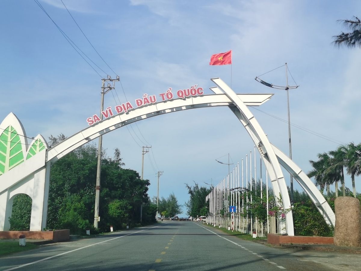
Cape Sa Vi, also known as Cape Got, is located in Mong Cai 1 Ward, Quang Ninh Province. This is the northeasternmost point of mainland Vietnam with coordinates 21°29'33" North and 108°4'5" East. This special location makes Cape Sa Vi the place to welcome the first sunrise on the northern mainland, bringing visitors sacred moments.
What makes Cape Sa Vi particularly attractive is its important role in Vietnamese history and geography. This is the starting point for the country's coastline of over 3,260 km, like the "first stroke" on the familiar S-shaped map. From Cape Sa Vi, Vietnam's sea border extends south, marking the nation's sacred sovereignty.
In the hearts of Vietnamese people, Cape Sa Vi is not merely a geographical boundary but also a symbol of national pride. This is where the vast sea, lush green casuarina forests, and the gentle Bac Luan river mouth converge, creating a picturesque natural landscape that anyone who sets foot here will admire.
Cape Sa Vi is not merely a geographical boundary but also a symbol of national pride. (Source: Collected)
1.2. History of the Name and Natural Characteristics
The name "Sa Vi" carries a profound meaning from ancient Sino-Vietnamese characters. "Sa" means sand, "Vi" means sand tail, envisioning a sandy land jutting out into the sea at the northeasternmost point of the Fatherland. This name not only accurately describes the natural terrain but also reflects the unique position of the area on the country's map.
In Vietnamese culture, Cape Sa Vi has always been present as a symbol of sovereign consciousness. Generations of Vietnamese people have been attached to this border land, considering it the origin of the S-shaped strip of the country. Legends have been passed down from generation to generation, contributing to the creation of a unique border cultural identity.
Nature has bestowed Cape Sa Vi with a captivating, pristine beauty. Smooth sandbanks stretch out, green casuarina forests sway in the sea breeze, and a wide estuary with gently lapping waves. The climate here is fresh and cool year-round, especially in the early morning when the first rays of sunlight cast upon the water, creating a picturesque and poetic scene. The space offers a perfect harmony between wild nature and profound historical value.
2. Guide to Traveling to Cape Sa Vi 2025
2.1. Traveling to Cape Sa Vi from Hanoi and Northern Provinces
The most popular choice to reach Cape Sa Vi from Hanoi is by coach or limousine bus. From major bus stations like My Dinh, Gia Lam, tourists can easily find many regularly scheduled buses departing daily to Mong Cai. Ticket prices range from 250,000 to 400,000 VND per trip, with travel time around 6-7 hours depending on traffic conditions and weather.
Reputable bus companies such as Ka Long, Ha Vy, and Dai Phat offer quality services with comfortable seats and cool air conditioning. To ensure a seat, especially during peak seasons, tourists should book tickets at least 1-2 days in advance. Daytime departures are preferred as they allow for enjoying the beautiful scenery along the way, particularly when the bus passes through the coastal areas of Quang Ninh.
For those who want to be in control of their time, traveling by personal vehicle is an excellent option. The optimal route from Hanoi, tourists can travel along National Highway 5 towards Lang Son or Bac Ninh, then turn onto National Highway 18 to pass through Pha Lai and Mong Cai. From the center of Mong Cai, continue driving along Tran Nhan Tong street and then straight through Trang Vi street to reach Cape Sa Vi. The total travel time for this journey is about 5 hours.
Along the way, tourists should stop in Ha Long City or Cam Pha to relax and prepare for the final leg of the journey. The ideal itinerary is to spend at least 2 days and 1 night to fully explore Cape Sa Vi , combined with a visit to Tra Co and enjoying the distinctive cuisine of Mong Cai.
The most popular choice to get to Mui Sa Vi from Hanoi is to travel by coach or limousine. (Source: Collected)
2.2. Intra-provincial travel from Mong Cai center to Mui Sa Vi
The distance from Mong Cai center to Mui Sa Vi is only about 8 - 13 km along the coastal Tran Phu – Tra Co road. Motorbikes are the most chosen means of transport. Taxis and ride-hailing taxis are also readily available for tourists at reasonable prices, especially convenient for families with young children or a lot of luggage.
Another interesting experience is traveling by bicycle to slowly explore the scenery on both sides of the road. The road leading to Mui Sa Vi is lined with lush casuarina forests, traditional fishing villages with coracles, and vast white salt fields stretching out. This scenery offers a sense of peace and closeness to nature that is rarely found elsewhere.
As Mui Sa Vi is located in a border area, tourists should remember to bring their valid Citizen ID card or passport to present when passing through border guard checkpoints. This is a mandatory regulation to ensure national security and defense. Along the way, tourists can stop at small rest areas to admire the beach, pine forests, or enjoy fresh seafood at rustic roadside eateries.
3. Unique symbols and structures at Mui Sa Vi
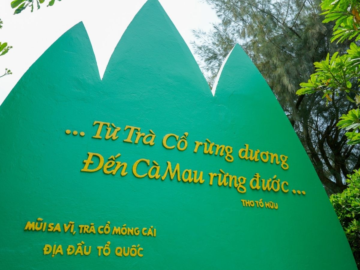
3.1. The bas-relief of 3 pine trees echoing Tố Hữu's poem
Upon arriving at Mui Sa Vi , visitors cannot miss stopping before the majestic bas-relief of 3 pine trees facing the sea. This work of art carries a profound meaning with two immortal lines from poet To Huu engraved on it: "…From Tra Co casuarina forest/To Ca Mau mangrove forest…". These lines not only describe geography but also evoke the image of a continuous north-south coastline, representing the unity of Vietnam's territory.
The three pine trees are designed to reach high, symbolizing the indomitable spirit and strong vitality of the Vietnamese nation. Each pine tree points in a different direction, as if embracing the sea and land, expressing the boundless aspirations of the people at the nation's frontier. This design not only has high artistic value but has also become a distinctive cultural symbol of Mui Sa Vi .
The bas-relief has become an unmissable check-in spot for all tourists visiting Mui Sa Vi . Standing before this work, many people feel moved to realize they are standing at the starting point of the S-shaped country. Photos taken here are not just memories but also carry historical significance, contributing to promoting the image of Vietnam's border region to international friends.
The bas-relief has become an unmissable check-in spot for all visitors to Mui Sa Vi. (Source: Collected)
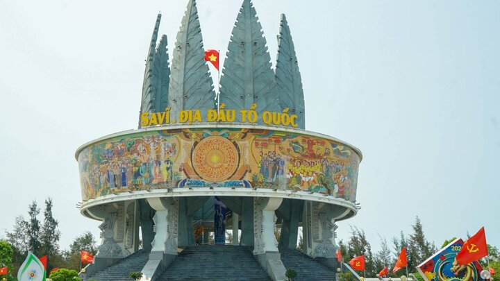
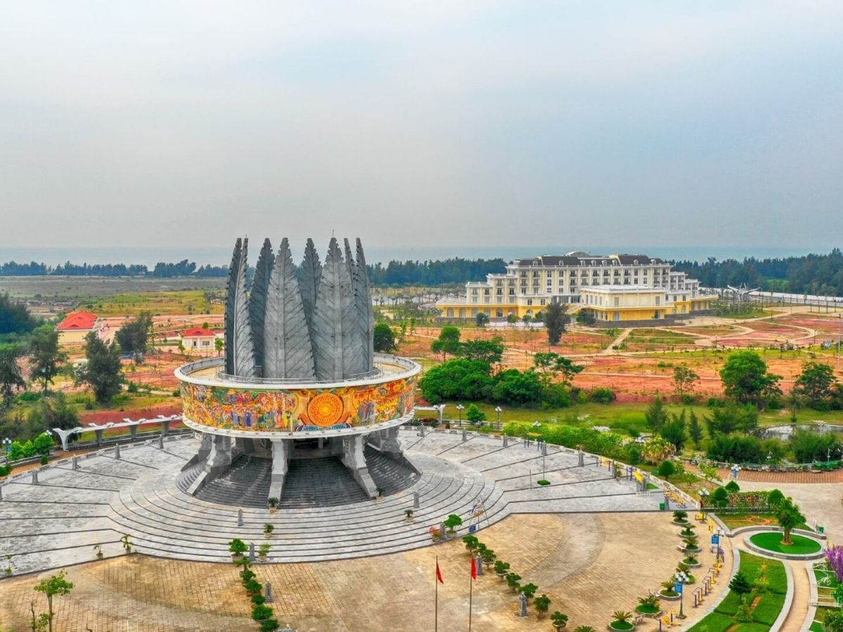
3.2. Sa Vi Border Propaganda Information Cluster: A Project Reaching Out to the Big Sea
The Sa Vi Border Propaganda Information Cluster is a modern architectural masterpiece designed to honor the natural beauty and historical value of Mui Sa Vi. The spacious central square area creates an airy space, suitable for community activities and cultural events. The highlight of the entire project is 8 galvanized concrete pine trees, each 27 meters high, arranged in a semicircle facing the sea.
Particularly impressive are the two rows of natural stone pillars transported from the Hoa Lu region, creating a sacred and solemn space. These stones not only have aesthetic value but also symbolize the connection between regions across the country. The overall design gives the impression that the entire project is reaching out to the big sea, embodying the Vietnamese nation's aspiration towards the ocean.
Exquisite artistic details such as images of the Dong Son drum and Lac birds are vividly recreated, creating a sacred atmosphere and national pride. This project was honored with the ASEAN Urban Sustainable Tourism Product Award 2020, affirming the position of Mui Sa Vi on the regional tourism map. It also demonstrates the efforts to develop sustainable tourism in border areas, contributing to the enhancement of international cultural exchange.
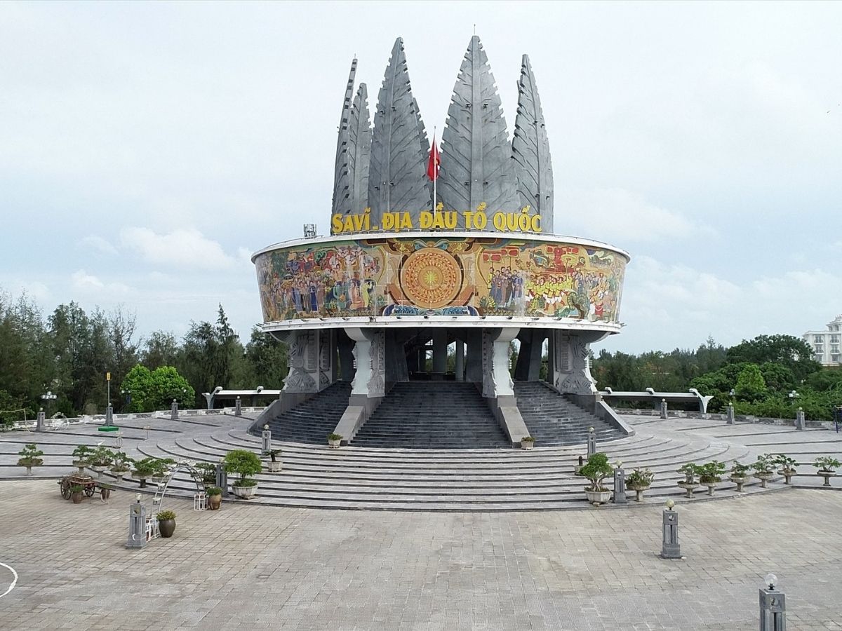
The Sa Vi Border Information and Propaganda Cluster is a masterpiece of modern architecture combining natural beauty and historical value. (Source: Lao Dong Newspaper)
3.3. Kilometer Marker 0 and Symbols of Sovereignty
The Kilometer Marker 0 at Cape Sa Vi is considered one of the most sacred symbols of the Fatherland. The marker is solemnly placed facing the sea, marking the starting point of Vietnam's coastline where all routes across the country begin. This is the "zero point" from which distances to all other places in the country are calculated, carrying special significance in asserting national sovereignty.
One side of the marker is engraved with "Trang Vi", another name for Cape Sa Vi, while the other side clearly states the distance to Cape Ca Mau, creating a symbolic connection between the two ends of the country. This figure is not just geographical information but also a reminder of Vietnam's unity and territorial integrity. Many tourists share that when standing before this marker, they feel the grandeur and continuity of the nation.
The area around the marker is designed as a solemn space, suitable for organizing ceremonies to honor the nation's history and culture. Visitors often spend time taking commemorative photos, considering it "real" proof of their journey to explore the country's northernmost point.
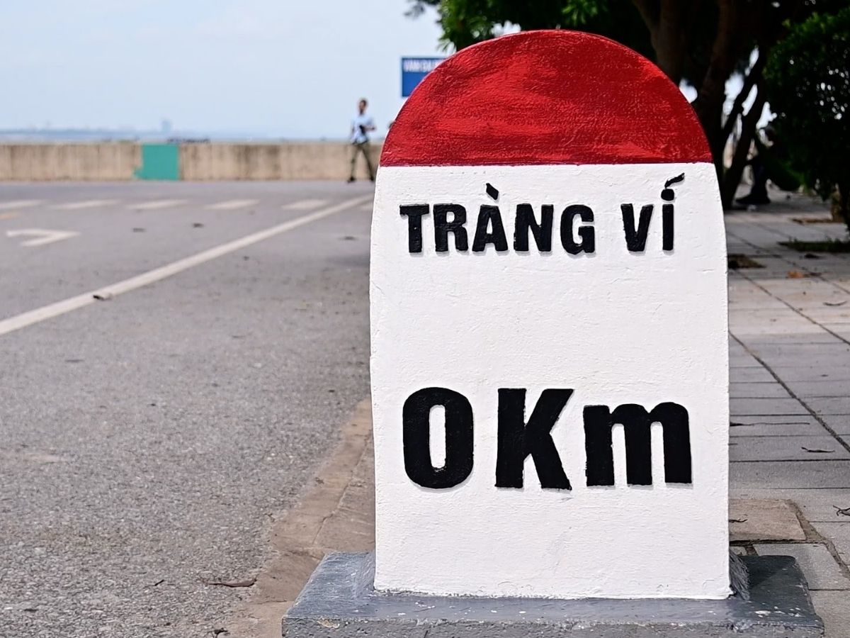
The 0 km Milestone at Mui Sa Vi is considered one of the most sacred symbols of the Fatherland. (Source: Collected)
4. Outstanding Experiences When Traveling to Mui Sa Vi
4.1. Cultural Activities, Folk Games, and Local Cuisine
Mui Sa Vi not only attracts tourists with its natural landscape but also with unique cultural activities. On weekends and holidays, the square area often organizes traditional folk games such as con throwing, tug of war, and sack jumping. These activities create opportunities for tourists to immerse themselves in the vibrant life of the border community, feel the spirit of solidarity, and the simple joy of the local people. Visitors can participate in group dances, learn traditional songs, or simply sit and enjoy the characteristic cultural rhythm of the border region.
The cuisine of Mui Sa Vi and the Mong Cai area is a highlight not to be missed. Grilled sandworms with their distinctive aroma, fresh and sweet raw clams, meaty sea crabs, and plump tiger prawns are fresh seafood delicacies that tourists must try. Coastal eateries serve charcoal-grilled seafood with the special seasoning of Tra Co sea, creating an unforgettable flavor. In the evening, enjoying seafood in an open space while gazing at the sparkling Mong Cai city at night and listening to the gentle sound of waves is a wonderful experience that few places can offer.
4.2. Exploring the Nature and Ecosystem of Mui Sa Vi
The lush green casuarina forest along the coast of Mui Sa Vi is a paradise for nature lovers. Winding trails through the forest create ideal conditions for hiking. The sound of the sea breeze blowing through the casuarina leaves creates a melodious natural symphony, helping tourists relax and find balance after busy days in urban life.
Camping overnight at Mui Sa Vi is an unmissable experience for those who want to live fully with nature. Sitting by the campfire at night, listening to the sound of the waves, and gazing at the starry sky are unforgettable moments. Waking up early to catch the first sunrise on the northern mainland is a privilege that only visitors to Mui Sa Vi can experience.
The final sandy area, the mouth of the Bac Luan river, and Trang Vi beach are ideal photo spots with their wild and poetic scenery. To maximize the experience, tourists should combine visits to Tra Co beach – known as the "most romantic beach in Vietnam", explore nearby Mui Ngoc, or participate in mangrove forest ecological tours. Linking with services within the SGR tourism ecosystem, such as ecological resorts and Mong Cai city tours, will provide a more diverse and rich experience for the trip.
5. Historical and Cultural Journey at Mui Sa Vi
5.1. Symbolic Value of History and National Sovereignty
In the consciousness of Vietnamese people, Mui Sa Vi is considered the "first stroke" when drawing the S-shaped map of Vietnam. The feeling of setting foot on this sacred cape is like marking the beginning of the entire long stretch of the country from North to South. This place connects the sea and islands with the mainland, marking the thousands-year tradition of defending the border of the Vietnamese nation.
Historical stories about Mui Sa Vi have been passed down through generations, each carrying lessons about patriotism and the awareness of protecting national sovereignty. Ancestors did not shy away from difficulties or sacrifices to preserve every inch of land at the country's northernmost point. Countless stories tell of border guards, fishermen, and local people who dedicated their lives to protecting and building this border region.
Visitors to this place often share special emotions that are difficult to put into words. "Touching Mui Sa Vi " is not just a physical act but also a deep spiritual experience. Many feel proud when they realize the "overall picture" of the vast country begins from this sacred location. This feeling helps everyone better understand the value of the country and the responsibility of each citizen in preserving and protecting the nation.
Mui Sa Vi is considered the "first stroke" when drawing the S-shaped map of Vietnam. (Source: Collected)
5.2. Mui Sa Vi in modern media and tourism
In recent years, Mui Sa Vi has become a destination of particular interest in tourism communication campaigns. The New Year's flag-raising event, cross-border running races, and annual art performances in the square area are increasingly organized on a large scale and attract a large number of people as well as visitors from all over. These events not only honor historical values but also contribute to promoting Vietnam's image on the international stage.
The image of Mui Sa Vi continuously appears in major media outlets such as Thanh Niên newspaper, Dân Trí, Vietnamnet, and VnExpress. Special reports on VTV and Quang Ninh Television channel have strongly promoted the image of the country's northernmost point to people nationwide and international friends. Its frequent appearance on digital platforms and social media has turned Mui Sa Vi into a famous tourist icon. Live tourism programs have also contributed to increasing the attractiveness of Mui Sa Vi . This not only supports the sustainable tourism development for Quang Ninh province but also contributes to enhancing Vietnam's position on the world tourism map.
6. Tips for preparation and experience exploring Mui Sa Vi
6.1. Clothing suggestions
The climate at Mui Sa Vi has many unique characteristics due to its coastal location and monsoon influence. Visitors should choose light, breathable clothing that still provides good protection against sunlight and sea wind.
Cotton or stretchy fabric clothing will provide comfort when moving between attractions.
Sports shoes with non-slip soles are the optimal choice for walking on sand and trails in the casuarina forest.
Protective accessories such as wide-brimmed hats, sunglasses, and high SPF sunscreen are essential items.
The sea breeze can be quite strong at certain times of the day, so it is advisable to prepare a light jacket or windbreaker for use when needed.
Mineral water, insect repellent, and basic medicines such as fever reducers and digestive aids should also be included in the preparation list.
6.2. Notes on border area movement and necessary procedures
As Mui Sa Vi is located in a border area, carrying personal identification documents is a mandatory regulation.
A valid Citizen Identity Card or Passport must be carried in its original form to be presented when requested by border guards.
Visitors must respect and strictly comply with local regulations, behaving civilly and politely towards officials on duty and local residents. Proactively declaring information when necessary will help the inspection process proceed smoothly and quickly.
6.3. Check-in experience, tips for beautiful photos at Mui Sa Vi
Natural light is the most important factor for beautiful photos at Mui Sa Vi . The periods of sunrise from 5:30 AM - 6:30 AM and sunset from 5:30 PM - 6:30 PM are considered the "golden hours" for photography.
The sunlight during these moments has a warm color, creating a beautiful natural lighting effect for the sea and casuarina forest scenery. Visitors should arrive early to choose a favorable spot and have time for thorough preparation.
The central square with the 3 pine trees bas-relief is the most classic photo spot. Standing at different angles around the square will create photos with depth and diverse perspectives.
The 0 km milestone should be photographed with a solemn pose, reflecting the historical significance of the location.
The casuarina forest area along the coast creates a beautiful natural picture when photographed angled towards the sea, giving a sense of depth and open space.
For large groups, taking group photos in front of iconic structures will create memorable moments. Group photos in front of the 0 km milestone are particularly meaningful, representing the entire group's "journey to the northernmost point.".
In addition, visitors should take the opportunity to capture natural moments such as walking on the sand, sitting under the shade of casuarina trees, or watching the sunset to get the most vivid and authentic photos.
Mui Sa Vi is not just a tourist destination but also a sacred symbol of national sovereignty and pride. It offers unique experiences from majestic natural landscapes, meaningful cultural structures, to exciting exploration activities. Set foot in the country's "first stroke," capture memorable moments, and share your exploration journey.